Weather Alert Philippines
Real-time monitoring, forecasts, and historical typhoon analysis
Tropical Cyclone Warning
Tropical Storm approaching Eastern Visayas. Expected landfall in 24-48 hours.
Official Weather Warnings
Always follow official PAGASA instructions during severe weather. In emergency situations, consult local authorities and official government sources for the most accurate and up-to-date information.
Latest Weather Updates
Official PAGASA video briefings

Public Weather Forecast issued at 5PM | March 24, 2026 - Tuesday
DOST-PAGASA Weather Report
Streamed 5 hours ago

Public Weather Forecast issued at 5AM | March 24, 2026 - Tuesday
DOST-PAGASA Weather Report
Streamed 17 hours ago

Public Weather Forecast issued at 5PM | March 23, 2026 - Monday
DOST-PAGASA Weather Report
Streamed 1 day ago
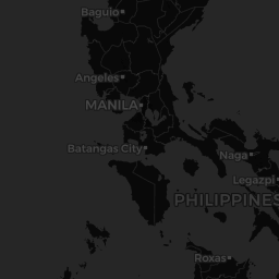
Understanding Weather Radar
What you're seeing:
Real-time precipitation radar showing rainfall intensity across the Philippines, updated every 10 minutes. Typhoon positions are marked with storm icons.
How to interpret:
Green shows light rain, yellow shows moderate rain, orange shows heavy rain, and red shows very heavy rain. Darker colors indicate more intense precipitation. Typhoon tracks show predicted paths.
What to do:
Use radar to track approaching storms and rainfall. If heavy rain (orange/red) is approaching your area, prepare for potential flooding. Monitor typhoon tracks for evacuation planning.


Manila
few clouds
Wind
2.6 m/s
SE
Humidity
65%
Pressure
1011 hPa
Quezon City
few clouds
Wind
2.6 m/s
SE
Humidity
66%
Pressure
1011 hPa
Cebu City
clear sky
Wind
3.1 m/s
N
Humidity
69%
Pressure
1010 hPa
Davao City
few clouds
Wind
0.5 m/s
W
Humidity
81%
Pressure
1010 hPa
Baguio
clear sky
Wind
0.9 m/s
W
Humidity
92%
Pressure
1014 hPa
Tacloban
few clouds
Wind
1.3 m/s
NW
Humidity
93%
Pressure
1010 hPa